PM Declares SOE In St Andrew South Police Division
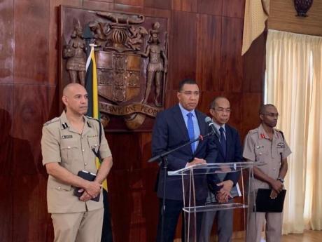
Prime Minister Andrew Holness today announced that a state of emergency has been declared in the police division of St Andrew South.
Holness said he advised the Governor General on the recommendation given to him by the heads of the security forces.
"In St Andrew South the main cause of death is caused by gangs," Holness said this morning with Police Commissioner Major General Antony Anderson and the Chief of Defence Staff Lieutenant General Rocky Meade standing by his side.
Holness made the announcement at the Office of the Prime Minister in St Andrew.
From January 1 to June 29, this year, there were 94 murders in St Andrew South, up from 79 for the corresponding period last year.
"Violence is at epidemic proportions in Jamaica ... the main cause of death is gangs, dons and guns," Holness said.
Currently, there is a state of emergency in effect in Westmoreland, Hanover and St James.
In January, a year-long state of public emergency expired in St James.
Only last week, Montego Bay mayor Homer Davis called for another saying people were living in fear with murders up by almost 50 per cent over the similar period last year.
Boundaries of St Andrew South State of Public Emergency:
EAST
Starting at the foot of Red Hills at the intersection of Perkins Boulevard, Molynes Road and Red Hills Road, extending in a south-south easterly direction along Molynes Road, Seaward Drive, Mimosa Road, Aloe Ave, Bay Farm Road, Newark Avenue, Elm Crescent, Keesing Avenue, Hagley Park Road, Omara Road, and Chisolm Avenue to the point of intersection with Maxfield Avenue.
SOUTH
Extending in a south-westerly direction from the intersection of Chisolm Avenue and Maxfield Avenue, along Maxfield Avenue onto East Avenue to the coastline in the vicinity of Petrojam and extending along the said coastline in the vicinity of the Kingston Container Terminal to the Portmore Causeway Bridge.
WEST
Continuing in a north-westerly direction from the Portmore Causeway Bridge along the Fresh River, the shared parish border of St Andrew and St Catherine west of Riverton, and extending to the vicinity of the western most end of the Belvedere to Ferry secondary road.
NORTH
Extending in an easterly direction along the Belvedere to Ferry road to the foot of Red Hills at the intersection of Perkins Boulevard, Molynes Road and Red Hills Road, the start point.
RELATED POSTS


admin